


The towns of the Geocaching Capital of Canada
The towns of the Geocaching Capital of Canada
The Geocaching Capital of Canada is made up of seven Hamlets.
Scroll down to read about more, or use the links below to jump to a specific town that interests you.
Irondale, Gooderham, Tory Hill, Wilberforce, Harcourt, Highland Grove, Cardiff
Irondale
Irondale
Irondale is the Geocaching Capital of Canada's community that is furthest to the west. Located on County Road 503, it’s one of the very earliest of Haliburton Highlands' settlements, originally called Devil's Creek. The settlement began in 1870 after large deposits of iron ore were discovered in the area by settlers. Peter Barr opened a general store in the area about 1873. Charles Pusey became involved in the iron mining of the area. It became evident the best method for transporting ore from the mine would be by rail, hence the building of the IB&O Railway began. In 1879, Pusey had the town site surveyed, drawn up and registered. The name Irondale was given to the town site at that time. By the mid-1880s Irondale had three hotels, boarding houses, a miner's cottage, a general store, and a barrel factory. Ruth Pusey (Charles wife) was very instrumental in having the Irondale Church built and opened in 1887. Mining lasted until 1900.
Today Irondale is a small community with a general store and auto repair shops. Permanent and seasonal residents can be found along the highway and hidden along the quaint Burnt River. Any obvious remnants of mining operations have long passed.
Gooderham
Gooderham
At the junction of County Road 503 and County Road 507, the community of Gooderham, originally named Pine Lake, was founded in 1873. It is nestled against what was also originally named Pine Lake, but is now called Gooderham Lake. Stories about the name change in the 1890s vary although all seem to involve Gooderham & Worts Distillery. Gooderham's main industries were farming and logging. The first sawmill was completed by 1875 using the waterfall between Gooderham Lake and the Irondale River. By the 1950s Gooderham was home to sawmills, three general stores, a barber shop, confectionery store, lodge and the infamous Skyline Dance Pavilion where people came for miles to dance to a live band. The IB&O Railway had a station in Gooderham until the early 1960s.
The present community of Gooderham offers a community centre, fire station, library, beach, post office, grocery store, butcher shop, restaurant, liquor store, and a building supply store.
Tory Hill
Tory Hill
At the junction of County Road 503 and Highway 118 in the quaint hamlet of Tory Hill, one can still see the effect of the railroads on small towns in earlier days. Though the common industries of rock and wood were scattered throughout the outskirts of town, the village of Tory Hill centred itself around the railway. Originally settled in the 1870s, Tory Hill expanded once the railway came through and ran three times a week from 1893 until 1960. In those peak years the community had four general stores, a school, church, cheese factory, town hall, blacksmith shop, two saw/shingle mills and a garage. The community was booming when uranium was discovered in the 1950s and three mines opened. The train whistles are no longer heard in Tory Hill but the hamlet still maintains its unique place in history.
Today Tory Hill offers great access to the old railway line which is now a multi-use trail network. The parkette also offers a play structure for children and ample parking. Stop and take a hike or just enjoy the parkette.
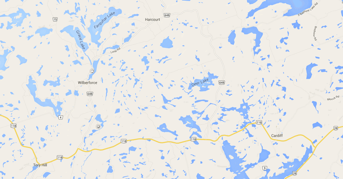
Wilberforce
Wilberforce
On County Road 648 (Loop Road), the original settlement was South Wilberforce on the shores of what is now known as Wilbermere Lake. After the development of the railway, many settlers migrated the four kilometres north to Pusey, a station on the IB&O Railway that was later named Wilberforce. Industry for Wilberforce at the time was much like Tory Hill, mining and logging. The Wilberforce Lumber Company built a sawmill where the railway lay along the southern shore of Pusey Lake, which is now called Dark Lake. In the early days Wilberforce featured a church, school, post office and store. The small town and its new inhabitants grew steadily to work in both the mines and logging camps. In 1922 the Red Cross Outpost opened in Wilberforce. It was the first Red Cross Hospital in Ontario and the first hospital of any kind in Haliburton County. In the 1950s mining and logging were both strong industries and the community continued to grow steadily.
Today, Wilberforce is a vibrant community. It is home to a community centre, arena, municipal office, fire station, curling rink, pharmacy, grocery stores, LCBO, restaurant, school, library, churches, post office, the Red Cross Outpost Museum, Royal Canadian Legion, realtor offices, storage units, a convenience store, a general store and other unique shopping opportunities.
Harcourt
Harcourt
North east of Wilberforce on Loop Road (County Road 648), Harcourt found its beginnings as a flagstop on the IB&O Railway called Mumford Station. One of the newer communities in the area, established in 1903 by the founding of its post office and store. In 1911 a railway station was built in the hamlet of Harcourt. The community grew mostly from the lumber industry. In its early years, Harcourt was home to a lumber mill, school, community centre, store and post office. There were numerous mines in the area including a graphite mine just west of the village.
Until the late 1980s Harcourt was home to the primary mill and headquarters of G.W. Martin Lumber. At the time of his death in a tragic plane crash in 1984, at age 48, Grenville Martin had assembled one of the largest hardwood operations in North America, with mills throughout Ontario serving markets around the world. County Warden Murray Fearey considered Grenville Martin to have had the most impact on the County of Haliburton of any one individual. Sadly, Martin Lumber went out of business shortly after his death, however the headquarters has since been repurposed as a resort and the majority of the remnants of the mill are still present.
Harcourt today features a restaurant, convenience store/gas station, storage units, community centre, church, building supply, unique shopping opportunities and more. A mere ten minutes north of Harcourt is the south entrance to Algonquin Provincial Park and access to many Provincial Park trails including a spectacular one to High Falls.
Highland Grove
Highland Grove
North east of Harcourt on the Loop Road (County Road 648) the small community of Highland Grove is rich in beautiful landscape. It is said to have been named as it was thought (at the time) to be the highest elevation in Haliburton County. Lumber was the largest industry in the area followed by farming. These hardy farmers were referred to as rock farmers due to the soil conditions. Highland Grove was home to three general stores, a cheese factory, two churches, a blacksmith shop, hotel and school as well as the railway station. Many of its original settlers came from other now abandoned communities where the railway did not go, such as Cheddar and Kidd's Corners.
Today Highland Grove features a community centre, library, museum/genealogy resource centre, fire station, church, unique shopping and a whole lot of community spirit. Be sure to check out the schoolhouse museum, especially if you are interested in genealogy.
Cardiff
Cardiff
Cardiff is the furthest community to the east on Highway 118 just off Highway 28. Cardiff began as a mining community, with uranium the chief mineral being mined for several years, beginning in 1956.
Cardiff is home to Ontario's largest dragonfly and many conveniences such as a school, several churches, a library, fire station, general store, gas station, community centre, public pool, Royal Canadian Legion, a kid’s summer camp and more.